A Pilot's Guide to Inflight Icing
Module I - Before You Fly
Know the Situation
Section: Weather - Frontal Effects
Start This SectionFrontal Effects Weather
When air masses of different temperatures, pressures, or relative humidity collide, a front is formed. The areas near fronts can be conducive to icing due to the enhanced lifting and moisture that may be present.
Warm Fronts
Cold Fronts
Occluded Fronts
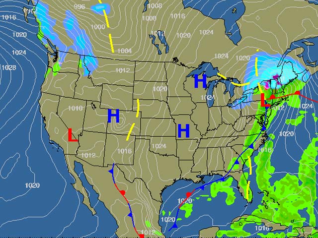
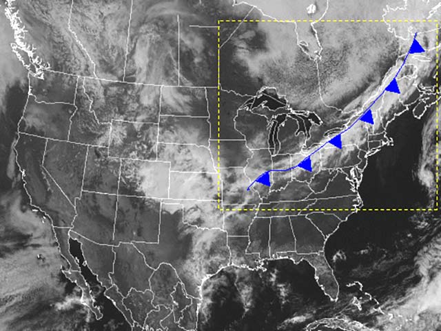
Weather chart showing frontal activity along eastern seaboard
Frontal Effects Weather
Warm Fronts
A warm front forms when warm air slides gradually over a cooler air mass. In the vicinity of a warm front, stratus cloud formations hundreds of miles ahead of the front are often apparent. During colder months, warm fronts can be very dangerous. Warmer air rising over a layer of sub-freezing air may result in the formation of freezing rain or freezing drizzle. As you approach the front, the cloud layers build quickly and the clear air between layers rapidly disappears.
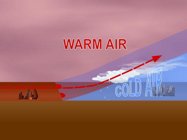
Warm front formation
Frontal Effects Weather
Warm Fronts
Pilot Action Recommendation
IF: Your planned route of flight will take you along a warm front.
ACTION: Consider traversing the warm front perpendicular to its direction of movement and flying behind it. Also, consider flying at alternate altitudes.
CUES: Examine the area forecast and Low Altitude Prognosis Charts.
WHY: Warmer air rising over a layer of sub-freezing air may result in the formation of freezing rain or freezing drizzle. However, in most cases, a change in altitude of 3,000 feet will take you out of the icing environment, although the icing environment in a warm front could be 10,000 feet thick or more. Because of the wide extent, lateral deviations are not practical.
Satellite Image of a warm front
Frontal Effects Weather
Cold Fronts
A cold front forms when colder air undercuts warmer air. There are two types of cold fronts:
The classic cold front is characterized by extensive cumulus cloud development which often straddles the front.
A shallow cold front is characterized by widespread stratus clouds behind the front.
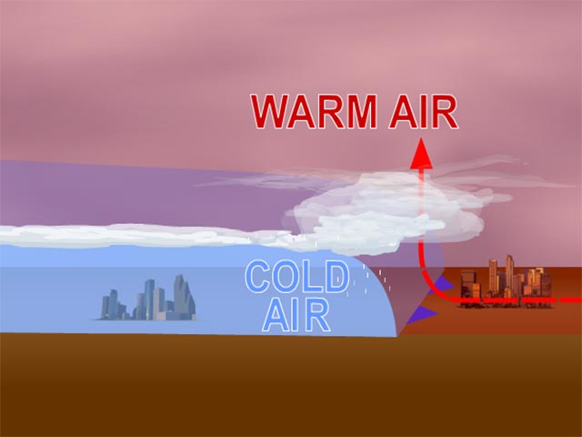
Cold front formation
Frontal Effects Weather
Classic Cold Fronts
Classic cold fronts are typically associated with the warm season. The intense lifting caused by the front usually limits the cloud development to narrow bands of clouds tens of miles wide near the surface location of the front. These convective clouds can develop into full blow thunderstorms with heavy precipitation, turbulence, hail, and high levels of supercooled liquid water.
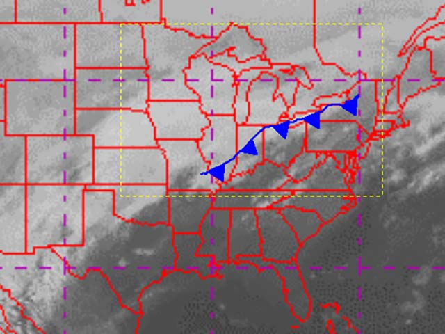
Satellite image of a classic cold front
Frontal Effects Weather
Classic Cold Fronts
Pilot Action Recommendation
IF: Your planned route of flight lies along a classic cold front.
ACTION: Consider traversing the front perpendicular to its direction of movement and flying behind it. Use standard thunderstorm avoidance techniques to avoid classic cold front icing. Do not rely solely on weather radar. Cells that are not yet visible on weather radar can produce substantial icing.
CUES: Examine the Area Forecast and Low Altitude Prognosis Charts.
WHY: The intense lifting associated with the front can produce substantial icing. However, the icing is usually limited in horizontal extent.
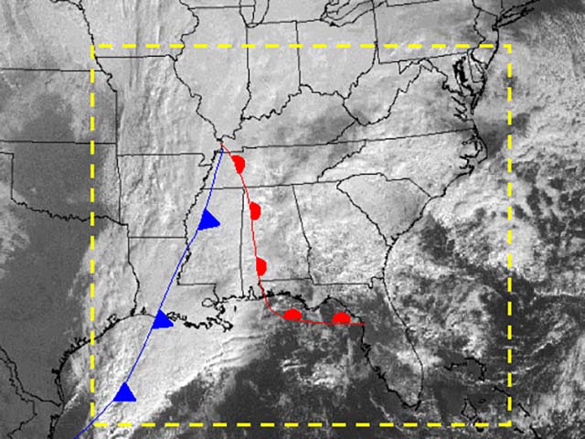
Satellite image of a classic cold front
Frontal Effects Weather
Shallow Cold Fronts
Shallow cold fronts are typically associated with the cold season. The widespread stratus clouds behind a shallow cold front can cover several states, but they are capped by a temperature inversion and typically not very deep – usually less than 5,000 feet.
Satellite Image of shallow cold front
Frontal Effects Weather
Shallow Cold Fronts
Pilot Action Recommendation
IF: Your planned route of flight is in the vicinity of a shallow cold front.
ACTION: Consider flying ahead of a shallow cold front. Be prepared to change altitude by 3000 feet if you encounter icing.
CUES: Examine the Area Forecast and Low Altitude Prognosis Charts.
WHY: Icing can be quite significant in these clouds, but it can typically be escaped by changes in altitude. A change in altitude of 3,000 feet will usually take you out of the icing environment in the stratus clouds behind a shallow cold front. Because of the wide horizontal extent, routing around this form of icing condition is not practical.
Satellite Image of shallow cold front
Frontal Effects Weather
Occluded Fronts
Occluded fronts occur when a warm air mass is trapped between two colder air masses and is forced to higher altitudes. Occluded fronts may combine the characteristics of both warm and cold fronts. The risk of having a severe icing encounter in freezing rain or freezing drizzle is higher in the vicinity of a warm or occluded front.
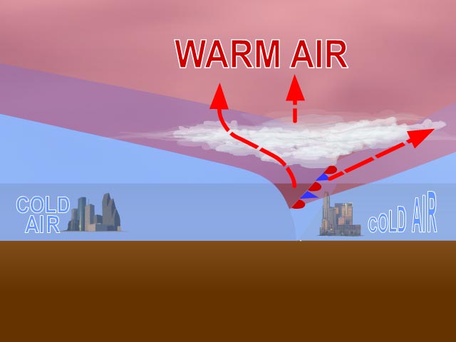
Occluded front formation