A Pilot's Guide to Inflight Icing
Module I - Before You Fly
Check the Weather
Section: Advisories
Start This SectionAdvisories Check the Weather
Step 2. Check the AIRMETs and SIGMETs
In the current aviation weather system, icing is directly forecast in:
AIRMET ZULU
SIGMETs
Center Weather Advisories (CWAs)
AIRMET Zulu provides forecasts for freezing levels and for moderate or greater icing.
SIGMETs contain forecasts for severe icing.
Center Weather Advisories (CWAs) for icing are issued when the conditions arise before an AIRMET or SIGMET can be issued or if the conditions are too localized to be included in an AIRMET or SIGMET.
Related Information
ZKC3 CWA 032140
ZKC CWA 301 Valid Until 032340
ISOLD SVR TSTM OVER KCOUD MOV SWWD 10 KTS.
Advisories Check the Weather
For conditions to be included in an AIRMET or SIGMET, the condition must occur or be forecast to occur over an area of at least 3,000 square miles. However, forecasters may use the term "local" to report icing conditions that have been reported over smaller areas.
Because of the transitory nature of icing, forecasters often use the term "occasional" in icing forecasts. Occasional is defined as a greater than 50% chance of occurrence for less than half of the forecast period.
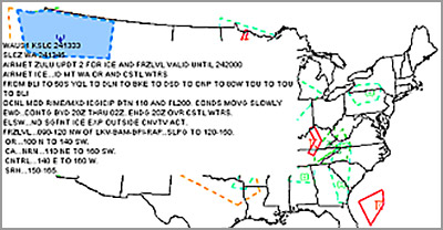
BOSZ WA 020245
AIRMET ZULU FOR ICE AND FRZLVL VALID UNTIL 020900
AIRMET ICE...ME NH VT NY
FROM 60NW PQI TO YSJ TO ALB TO YOW TO 60NW PQI
OCNL MOD RIME/MXD ICGICIP BLW 100. CONDS CONTG BYD 09Z THRU 15Z.
Example of text AIRMET ZULU
Advisories Check the Weather
AIRMET ZULU
AIRMETs (AIRman's METeorological information) advise pilots of weather that may be particularly hazardous to light aircraft and VFR pilots.
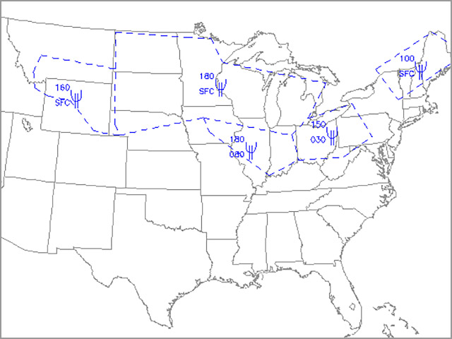
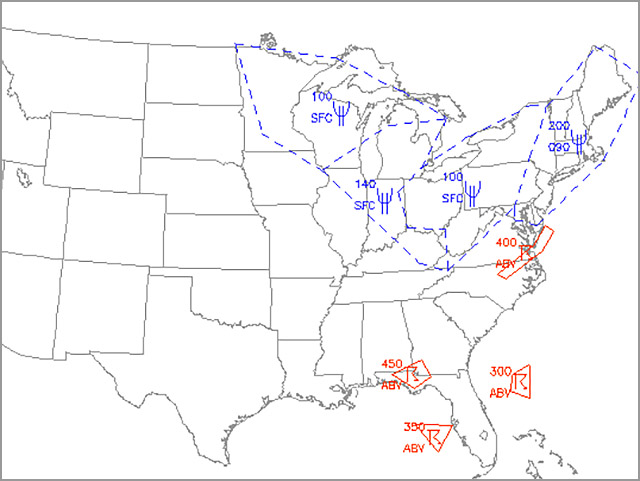
AIRMET ZULU contains icing information that is valuable to all pilots by reporting forecasts of moderate icing, freezing levels, and occasionally the presence of freezing drizzle or freezing rain aloft.
The location of the forecast icing is described using geographic areas and altitude ranges with specific bases and tops. Areas in which trace or no icing is forecast are indicated by the phrases "No significant icing expected" (NO SGFNT ICING EXPD) or "No significant icing expected outside convective activity (NO SGFNT ICING EXPD OUTSIDE CNVTV ACTVTY)."
CHIZ WA 020245
AIRMET ZULU FOR ICE AND FRZLVL VALID UNTIL 020900
.
AIRMET ICE...IA MO IL IN
FROM FOD TO FWA TO CVG TO PXV TO DSM TO FOD
OCNL MOD RIME/MXD ICGICIP BTN 080 AND FL180. CONDS MOV EWD AND
CONTG BYD 09Z THRU 15Z.
Example of text AIRMET ZULU
Advisories Check the Weather
AIRMET ZULU
In addition to general warning of possible icing conditions, advisories may warn of SLD conditions or local occurences of severe icing. You should interpret "icing in precipitation" as "freezing drizzle or freezing rain". Specific examples are:
CLR ICGIP = clear icing in precipitation
MXD/CLR ICICIP = mixed or clear icing in clouds or precipitation
FZDZ/RA ALF = freezing drizzle or freezing rain aloft
AIRMET ZULU describes the location, intensity, and type of non-convective icing only. Thunderstorm activity always implies severe icing so a separate advisory is not issued.
AIRMETs are issued 4 times a day, valid for 6 hours with an additional 6-hour outlook, and updates as required.
Example of an interactive, graphical AIRMET for icing
Advisories Check the Weather
SIGMETs
SIGMETs contain forecasts for severe icing.
Convective SIGMETs forecast tornados, hail greater than or equal to 3/4-inches in diameter, surface winds greater than or equal to 50 knots, severe thunderstorms, embedded thunderstorms, lines of thunderstorms, or level 4 thunderstorms affecting 40% or more of an area of at least 3,000 square miles. They are issued for periods of up to 2 hours and may refer to "occasional" conditions.
Thunderstorm activity always implies the potential for severe icing. For obvious reasons, pilots should avoid those areas defined within convective SIGMETS.
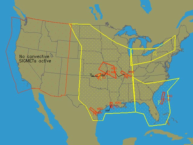
Example of convective SIGMET
Related Information
MKCC WST 132255
Convective SIGMET 50C
Valid until 0055 Z
AL MS
From 40E GRW-60WSW MGN-30E MCE-40E GRW
AREA TSTMS MOVG FROM 2620. TOPS TO 350
Interpretation
A convective SIGMET for the Central Region was issued on the 13th day of the month at 2255 Z. Valid until 0055 Z and covering AL and MS. The area is bounded by a line connecting Greenwood-Montgomery-Macomb-Greenwood. An area of thunderstorms is moving from 260 degrees at 20 knots. Tops extend to 35,000 feet.
Note: All convective SIGMETS are issued by the NWS in Kansas City, Mo.
- MKC is the office identifier
- The trailing "C" in the identifier (MKCC) indicates "Central Region"
- The letters "WST" in the first line indicate a SIGMET
- The term "50C" in the second line indicates the SIGMET number
Advisories Check the Weather
Center Weather Advisories (CWAs)
Center Weather Advisories (CWAs) are unscheduled in-flight advisories issued when conditions are expected to significantly affect IFR operations.
They are intended to supplement previously issued AIRMETs and SIGMETs in between the normal update cycles for these products. They may also be issued when conditions are too localized to warrant an AIRMET or SIGMET.
Air Route Traffic Control Centers (ARTCC) issue CWAs (usually verbally) for conditions expected to begin within the following 2 hours.

If the weather changes unexpectedly, ATC may issue a weather advisory
Related Information
ZKC3 CWA 032140
ZKC CWA 301 Valid Until 032340
ISOLD SVR TSTM OVER KCOUD MOV SWWD 10 KTS.
Advisories Check the Weather
Because icing conditions are often transitory and limited in geographical extent, the value of AIRMETs and SIGMETs for evaluating the risks of icing encounters at a specific time and location is limited.
In most cases, if the forecast conditions are not expected to affect an area of at least 3,000 square miles no AIRMET or SIGMET will be issued. AIRMETs and SIGMETs are not always issued for local occurrences. Advisories are not issued for each report of icing and icing conditions can develop before advisories are released.
You cannot rely entirely on AIRMETs and SIGMETs to effectively assess the risk of icing.
Seneca in flight